I do not claim to know much about fire weather beyond the Northern California foothills and the Sierra Nevada—the country stretching roughly from Sutter's Fort northward to the Oregon border.
I have a fair understanding of what lies westward toward the Coast Range and its inland valleys, and southward toward the land of angels and the deserts surrounding her. But the intimate relationship a man develops with his own country—the almost instinctive knowledge that allows him to move through it without thinking—begins to slip away once I travel beyond the Sierra and foothills of Northern California.
That was why, whenever I responded to a fire beyond my own backyard, I learned to question the people who lived there: ranchers, homesteaders, anglers, timbermen, and anyone else who had spent enough years watching weather move through that country.
Such people might not have spoken in the language of weather stations or fire-behavior manuals, but they understood the land they kept. They knew which draws collected the afternoon wind, which ridges dried first, and where a fire was likely to go once it had made up its mind.
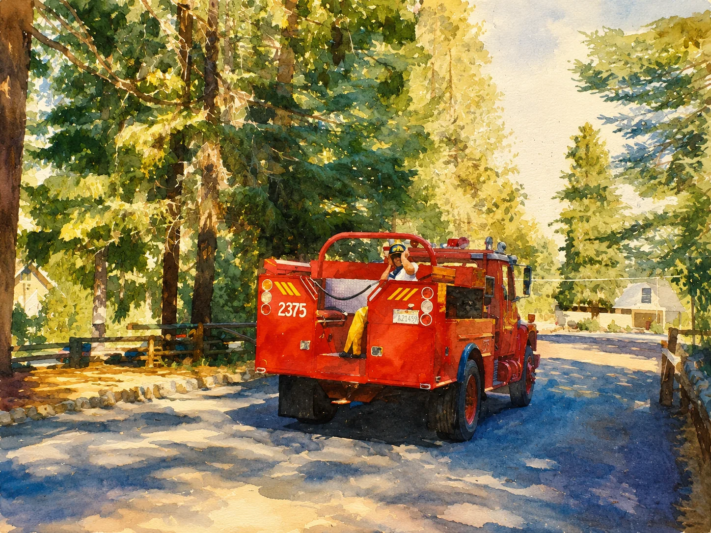
In 1990, as a new rookie among the overlanders, I went north as part of a wagon-wheeled CDF strike team—a column of steel horses with a scout riding ahead in a Dodge pickup. We formed up at James Smart's town of Smartsville, a little station above the placer diggings and steep canyons of the Yuba River country. There we saddled up and turned north.
I rode in the rear of an International engine with a couple of other young Argonauts as we followed the long trail of Highway 99 through the heat of the Sacramento Valley. There were only brief moments of relief as we crossed bridges over creeks holding what little water remained at that time of year.
The road unrolled beneath us mile after mile, carrying us away from the country we knew and toward smoke lying somewhere beyond the horizon.
Our fire, which I believe would eventually merge with the Campbell Fire, was burning east of Dairyville, a small, unincorporated settlement in Tehama County. It was unfamiliar country to some of us. We carried maps, radios, hand tools, hose, and all the confidence of firefighters moving toward a distant column of smoke. But the land itself remained a mystery, waiting ahead like an army drawn up beyond the next ridge.
It was still hot when we arrived, though stars had begun to appear in the eastern sky. We stopped along the shoulder of a side road, where our leader gathered us around his Dodge, unfolded a map across the hood, and pointed toward three separate fires burning in the grasslands beyond.
"Choose your fire," he said. And just like that, ours was chosen.
We turned eastward into the great anvil of volcanic country running west from Lassen. The land had not yet surrendered the heat it had gathered during the day. The black rock held it close and breathed it back upon us after sundown.
There was no comfort in the darkness, nor in the narrow ranch road that carried us along Dye Creek toward a grass fire moving through the hills above. For nearly an hour we rode over that road, pitched from one side of the engine to the other in what remains, in my memory, the most uncomfortable journey I ever endured on the back of that steel wagon. Dust rose behind us and entered through every opening. The suspension struck each rut as though the road had been laid deliberately to punish the crew traveling upon it.
Our tools of the trade—Pulaskis, McLeods, and a few regular old shovels—clinked and clanked within their rubber garments on the side of the engine. One could always hear our kind of wagon miles away, as if gold miners with pick and axe were announcing their presence to every bear and cougar within a ten-mile radius.
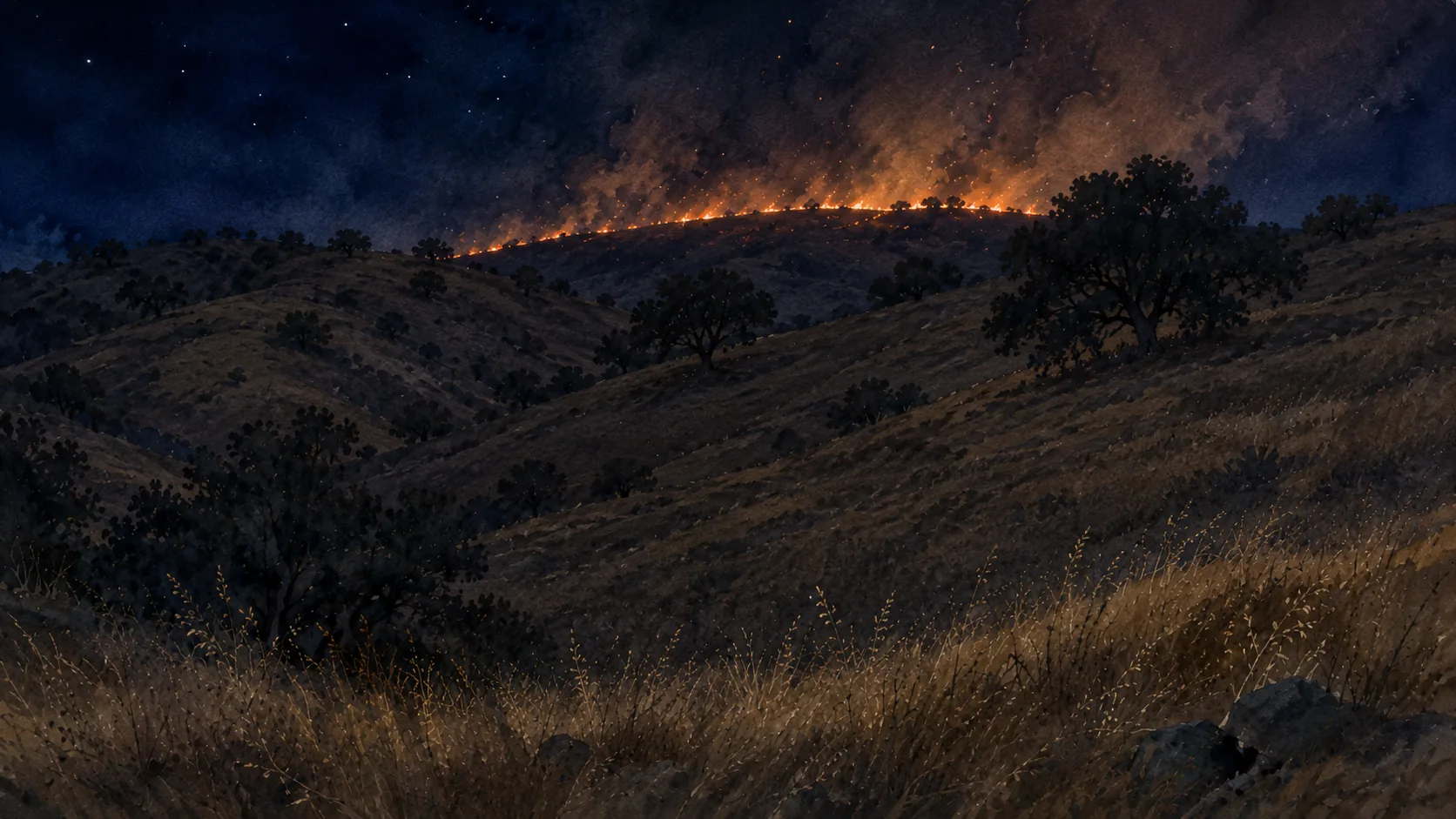
By the time our carriage reached the fire line, the country had gone completely dark except for the red light of the fire. It burned along an extended front running east to west, marking the hills in a broken line of flame that appeared and disappeared among the grass and lava rock.
Captain Bud Wood, a most confident and patient leader of our wagon—one would call him a Shambhalic master of fire and of the meditation of the present moment—ordered us to dismount. We climbed down stiff-legged, collected ourselves, and waited while he walked over to speak with a local rancher sitting beside his International Scout.
The rancher began telling him about the cattle country—the trails through the lava beds, the fences, the rough ground, and the places where a man unfamiliar with it might come to grief. Then he pointed into the darkness beside us.
"There's a drop-off right over here," he said. "You don't want to get too close to it."
There was nothing dramatic in the way he said it. He spoke as a man describing a gate left open or a bull loose in the lower pasture. Yet the warning carried the authority of someone who knew precisely where he stood, while the rest of us could see no farther than the reach of the flames and our own headlights.
It was a long, hot night. Even the crickets seemed unable to settle in the heat. Every so often the Midland radio broke the darkness with its familiar beep-beep, followed by the voice of our fearless leader calling from his Dodge, cowboy boots and all. "2375, how does it look over there?" And so it went through the night.
When the fire allowed it, we tried to sleep, curled like wild coyotes beside the great black tires of the wagon while heavy black flies buzzed around our faces. Rest came only in scraps. Still, we kept the fire on our right flank and stayed well clear of that sudden drop into death the rancher had warned us about.
This was my first out-of-county assignment. I was nervous, though I tried not to show it. More than anything, I did not want to disappoint the rest of the crew riding that wagon.
Source: NOAA NCEI daily summaries (GHCND) · IEM ASOS gap-fill · values are daily maximum °F · plotted by day of season (Jun 1 →)
Source: NOAA NCEI daily summaries (GHCND) · IEM ASOS gap-fill · values are daily maximum °F · plotted by day of season (Jun 1 →)
Sitting beside that diesel engine through the night, I possessed at least an intuition about heat and air, though I lacked the language to explain it. The air felt brittle, like a dry rag left all day upon the hose rack, baked stiff beneath the sun. The atmosphere seemed to have no moisture left to give and no willingness to receive any in return.
I already knew by feel that a California heat wave carrying southern tropical moisture was a different beast from one born beneath a dry continental sky. Both could be brutally hot, but they did not breathe the same. The moist heat pressed against the body like a wet blanket. The dry heat seemed to pull water directly from the skin, the grass, and the wooden handles of our tools.
That much I understood through instinct. The science had not yet found its way into my hands.
I knew nothing then of vapor pressure deficit, or VPD, and could not have explained why the air on that ranch felt so brittle. I did not understand that temperature alone tells only part of the story. What matters is the distance between the moisture actually present in the air and the amount the air could hold at that temperature. The greater that distance, the greater the atmosphere's demand for water.
Vapor pressure deficit is, in a sense, a measure of how thirsty the air has become—how strongly it demands moisture from fuels, soil, and living vegetation.
Nor did I understand how closely that atmospheric demand was tied to the moisture held within the fuels. In dead grass, needles, leaves, and small branches, the response can be direct and swift. As VPD rises, those fuels surrender moisture and move toward equilibrium with the air surrounding them.
Living brush and timber answer more slowly and by more complicated means. Their condition depends upon soil moisture, rooting depth, plant species, season, and their ability to close their leaves against further loss. Yet they, too, reveal the strain when the atmosphere continues asking for water the earth can no longer provide.
That science came later. On that night I possessed only the evidence of my senses. The heat was not merely resting upon the landscape. The atmosphere was actively taking something from it, restless as children who had eaten too much chocolate and remained awake long past bedtime.
Equilibrium moisture content via the Simard (NFDRS) equations · fuels desorb when above EMC (hot, dry afternoons) and adsorb when below it (humid nights)
Peak VPD ≈ eₛ(Tmax)·(1 − RHmin/100), Tetens saturation curve · RH from IEM ASOS, temp from NOAA NCEI · higher = thirstier air pulling moisture from fuels
Note: Chico's 1990 hourly humidity record is partial (~57 of 122 days), so its 1990 VPD line is intermittent. Redding's 1990 record is complete.
Picture the oldest chore on the place: a wet rag, and a pair of hands wringing it out.
The hands are the air. Vapor pressure deficit is how hard they twist—gentle on a cool, damp morning, savage by mid-afternoon when the heat leans into them. The rag is the fuel. Equilibrium moisture content is the dampness left in the cloth once the twisting and the cloth's own grip have come to terms.
Twist harder—let the deficit climb—and less water stays behind. Ease off in the cool of the night, and the cloth draws moisture back out of the air. The two are forever bound: the strength of the hands sets the dampness of the rag. One rises only as the other falls.
VPD is the strength of the wringing. EMC is what the cloth has left to give.
And the cloth matters as much as the hands. A thin handkerchief surrenders its water the instant it is squeezed—that is the fine grass, dry within the hour. A folded saddle blanket gives up its moisture slowly, grudgingly, days behind the weather—that is the heavy timber, still holding the memory of a wetter month.
I had felt those hands on Dye Creek long before I knew their name. The grass beneath my boots was a handkerchief already wrung dry. The air only had to twist.
Source: NOAA nClimDiv monthly precipitation, California Division 2 · normal = 1991–2020 mean. The 1990 water year finished near 71% of normal — a genuinely dry year — while the current water year tracks near normal. The fire ran on a real rainfall deficit, sharpened by extreme heat and a thirsty atmosphere. Monthly data posts about six weeks in arrears, so the current line runs through the latest published month (the marked point) — e.g. June appears in mid-July.
The fire continued consuming the grass through the darkness, though its behavior changed little until shortly before sunrise.
At first light, we began a firing operation along a line running parallel to Highway 99, which lay somewhere to our west. The sun climbed above the volcanic country and once again became an anvil, beating down upon us without mercy. With little sleep behind us—REMSD, or REM sleep deficit; funny how those two (VPD and REMSD) go hand in hand—it seemed as though the weight of the sun itself were pressing upon our shoulders, trying to drive us into the earth.
That assignment marked the beginning of my fascination with the convergence of weather and fire. It was well before the internet, before we could summon weather maps and current conditions with a few taps upon a screen—or wait while they arrived through the slow electronic chatter of a 14.4-kilobit modem.
California is a vast and restless playground of wind and air—more varied, I believe, than that of any other state.
Marine air creeps inland through the Delta. Desert winds can descend from the Great Basin. Southern moisture sometimes travels north from Mexico and the eastern Pacific, popping thunderstorms across the high country during the summer monsoon. Mountain ranges bend, divide, compress, and redirect them all.
Heat settles into valleys while cool air drains down canyons. Offshore winds descend and warm as they compress. Marine air works inland through gaps and river channels, sometimes advancing only a few miles before the mountains stop it. Somewhere among those competing movements, fire finds its opportunity.
I did not yet understand all of that. But the first sense of its importance was laid upon me there, standing in the darkness on that rancher's ground, looking into the fire and smelling the hot grass, dust, cattle country, and volcanic rock.
The weather and the fire were not separate things. They were moving together across the land, joined as surely as two armies advancing upon the same field.
I make no pretense of being a meteorologist. I hold that profession in high regard, especially the Incident Meteorologists—the IMETs—who still go into the field and stand beside the men and women working the fire.
I have only tried, over the years, to learn the patterns of this state: to read the models, compare their competing solutions, and play a poor man's Nostradamus among the computed outputs, searching for some agreement about what the atmosphere intends to do next.
The models are impressive, but California has never been overly concerned with what a computer expects of it. The Coast Range, the Sierra, the deserts, the Delta, and the long Central Valley all interfere with one another, bending and redirecting the air until a forecast that appeared certain upon a screen becomes something quite different upon the ground.
That uncertainty is what keeps me looking.
Special thanks to Chief Terwilliger and Zeke Lunder for refreshing my memory — though as it stands, still scattered among the lava rocks.